
Translate a compass direction into route exposure
A weather report names wind by the direction it comes from. A north wind comes from the north. Graphical arrows can use different conventions, so read the legend rather than guessing from an arrowhead. Outgoing Tide's Homebase and hourly arrows show travel direction; the direction labels and source context help interpret them. Check the relevant display before comparing it with another provider.
Now divide the route into parts. A launch tucked behind land, an open river reach, and an inlet approach have different exposure. Ask whether wind crosses open water toward each segment or comes over nearby land first. The apparent comfort of the first few minutes is a poor basis for judging the most exposed part of a trip.
Fetch explains some of the difference
Fetch is the stretch of water across which wind can act. With other factors comparable, more open-water distance gives wind more opportunity to build local waves. Direction changes can therefore matter even when the displayed speed stays similar. A sheltered bank can lose its shelter when the wind shifts.
Around St. Augustine and the Matanzas River, plan for bends, open reaches, and exposed crossings as separate segments. This is a route-reading exercise, not a claim that a particular compass direction always makes the entire river calm. Obstacles, local gusts, and conditions beyond the shore you can see still matter.
Onshore and offshore are relative terms
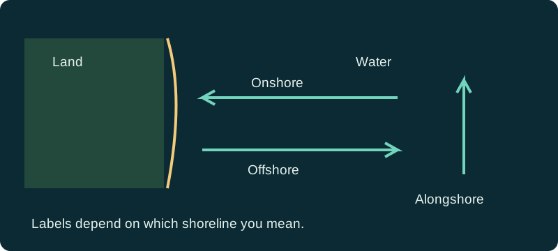
Onshore wind blows toward the shore you are discussing; offshore wind blows away from it. Alongshore wind runs roughly parallel. Those labels need a named shoreline. A wind described as offshore at the ocean beach can have another relationship to a winding creek or a different bank of the river.
Offshore does not mean safe. Water close to a sheltered beach may look flatter while a paddler is being pushed away from an easy return. Onshore wind can add chop and make landing harder. Think about where the boat or person would drift if propulsion failed, as well as how comfortable the outbound leg might feel.
Read gusts and the return forecast
The sustained or representative wind value does not capture every short burst. Gusts can affect control, balance, docking, and handling. Read both values and check the timing of expected changes. A return trip into stronger wind can be substantially more demanding than the departure even if the distance is identical.
On the dashboard, compare current guidance with the hourly forecast through the planned return. Model values are not a sensor on your vessel, and a broad forecast cannot resolve every protected corner. If the official marine forecast describes stronger or more uncertain conditions than a convenient hourly value suggests, resolve that conflict before leaving.
Wind and current must be considered together
Water moving against wind or incoming waves can change the sea surface and produce steeper, more difficult conditions. Do not assume that the tide table identifies the exact current direction or turn time at an inlet. Consult suitable current information and local guidance separately.
Wind can also affect water levels, but a compass direction is not a universal formula for how many inches to add to a tide prediction. Geography and the duration of weather matter. Use available observations and official forecasts to investigate departures from predictions rather than calculating an unsupported local correction.
Hypothetical planning example: an easy outbound paddle
A paddler considers crossing an open reach with wind behind them. The hourly outlook shows a stronger breeze later. They mark the exposed crossing and compare the return direction, landing options, current information, and time required to get back. The quick outbound estimate no longer looks like a realistic round-trip estimate.
They choose a shorter route with more suitable access or postpone if the uncertainty exceeds their ability. A favorable tide or attractive solunar period does not change that decision. The example intentionally gives no universal wind-speed limit: vessel design, skill, water temperature, waves, traffic, and rescue options all affect the consequences.
Use wind as one part of a decision
Before departure, identify the most exposed segment, the expected gusts there, the direction of the return, and an alternative landing or cancellation plan. Recheck official marine warnings and nearby conditions. Boaters should consider maneuvering at the ramp and dock; shoreline anglers should consider spray, surf, and the safety of footing.
The dashboard makes comparisons easier, but no colored arrow is permission to proceed. When live values fail to load, use the source links and the marine forecast directly. Treat missing wind information as missing, not calm, and never substitute a remembered earlier value for a current assessment.
References and data sources
Sources support the physical concepts and data definitions. Planning examples are hypothetical, not field reports or forecasts for a particular day.